
Site Data
East Dunbartonshire Kirkintilloch
Latest Data: Updated 18/07/2026 22:00 GMT
| Pollutant | Index | Band | Concentration | Period |
|---|---|---|---|---|
| PM2.5 | 1 | LOW | 6 µg/m3 (Ref.eq) | 24 Hour mean |
| PM10 | 1 | LOW | 10 µg/m3 (FIDAS) | 24 Hour mean |
| NO2 | 1 | LOW | 11 µg/m3 | hourly mean |
| PM1 | No Data | 6 µg/m3 (FIDAS) | 24 Hour mean | |
| NO | No Data | 3 µg/m3 | hourly mean | |
Mouse-over the graph to access further tools to analysis the data.
| Parameter | Parameter Name |
|---|---|
| NO | Nitric oxide |
| NO2 | Nitrogen dioxide |
| PM10 | PM10 particulate matter (Hourly measured) |
| PM2.5 | PM2.5 particulate matter (Hourly measured) |
| PM1 | PM1 particulate matter (Hourly measured) |
Statistics for East Dunbartonshire Kirkintilloch
| Site Name | East Dunbartonshire Kirkintilloch |
|---|---|
| Site Type | Roadside |
| Easting, Northing | 265683.75, 673520.86 |
| Latitude, Longitude | 55.935921, -4.151759 |
| OS Grid Ref | |
| Address | |
| Site Comments | Kirkintilloch Townhead Parliament Road. The nearest road is 0.5m from the site. |
| Monitoring Network: Scottish Automatic Urban Network | ||
|---|---|---|
| Parameter | Date Started | Date Ended |
| PM1 particulate matter (Hourly measured) | 06/03/2017 | |
| PM2.5 particulate matter (Hourly measured) | 06/03/2017 | |
| Modelled Temperature | 01/08/2010 | |
| Nitric oxide | 03/08/2007 | |
| Nitrogen oxides as nitrogen dioxide | 03/08/2007 | |
| Modelled Wind Speed | 01/08/2010 | |
| Nitrogen dioxide | 03/08/2007 | |
| Non-volatile PM10 (Hourly measured) | 03/08/2007 | 05/03/2017 |
| Modelled Wind Direction | 01/08/2010 | |
| PM10 particulate matter (Hourly measured) | 03/08/2007 | |
| Volatile PM10 (Hourly measured) | 03/08/2007 | 05/03/2017 |
The photographs show the site itself, and views looking North, East, South and West.
-
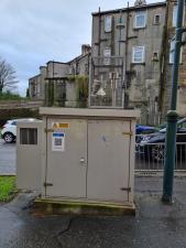
Monitoring Site Photo
-

View North
-

View East
-

View South
-

View West