
Site Data
N Lanarkshire Croy
N Lanarkshire Croy closed on 25/11/2024
You can still view any information available using the Site Information tab, or find data in the Data section.
For more information on this monitoring data please contact this local authority.
N Lanarkshire Croy closed on 25/11/2024
You can still view any information available using the Site Information tab, or find data in the Data section.
Statistics for N Lanarkshire Croy
| Site Name | N Lanarkshire Croy |
|---|---|
| Site Type | Roadside |
| Easting, Northing | 272770.40, 675740.30 |
| Latitude, Longitude | 55.957778, -4.039444 |
| OS Grid Ref | |
| Address | |
| Site Comments | The nearest main road is 5m from the site |
| Monitoring Network: Scottish Automatic Urban Network | ||
|---|---|---|
| Parameter | Date Started | Date Ended |
| Total particulate matter | 05/07/2018 | 25/11/2024 |
| Ambient Temperature | 01/10/2007 | 09/01/2012 |
| Carbon monoxide | 26/05/2010 | 05/04/2018 |
| Modelled Wind Speed | 01/08/2010 | 25/11/2024 |
| PM2.5 particulate matter (Hourly measured) | 05/07/2018 | 25/11/2024 |
| Wind Direction | 01/10/2007 | 09/01/2012 |
| Nitric oxide | 01/10/2007 | 25/11/2024 |
| Modelled Wind Direction | 01/08/2010 | 25/11/2024 |
| Sulphur dioxide | 01/10/2007 | 05/04/2018 |
| Wind Speed | 01/10/2007 | 09/01/2012 |
| Nitrogen dioxide | 01/10/2007 | 25/11/2024 |
| PM1 particulate matter (Hourly measured) | 05/07/2018 | 25/11/2024 |
| Nitrogen oxides as nitrogen dioxide | 01/10/2007 | 25/11/2024 |
| Modelled Temperature | 01/08/2010 | 25/11/2024 |
| PM10 particulate matter (Hourly measured) | 01/10/2007 | 25/11/2024 |
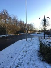
The photographs show the site itself, and views looking North, East, South and West.
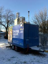
Monitoring Site Photo

View North
View East

View South

View West